October 2018
Contents
- General Announcements
- 2018 ILRS Governing Board Election Results
- Call: International Climate Protection Fellowship
- Meeting Announcements
- Meetings Calendar
- IAG Sponsored Meetings
- IGS 2018 Workshop
- International Workshop on GNSS Ionosphere (IWGI2018)
- 21st International Workshop on Laser Ranging
- 4th Joint International Symposium on Deformation Monitoring (JISDM)
- EUREF Symposium 2019
- 27th IUGG General Assembly
- IAG Related Meetings
- ITSNT
- AGU 2018 Fall Meeting
- 11th European Space Policy Conference
- Munich Satellite Navigation Summit 2019
- EGU General Assembly 2019
- ESA Living Planet Symposium
- AOGS 16th Annual Meeting
- Earth & Geo Science-2019
- 4th Symposium of the Committee on Space Research (COSPAR)
- Reports
- Report of Gravity Geoid and Height Systems 2018 – GGHS2018
- Obituary
- Prof. Dr.-Ing. Hermann Maelzer (1925 – 2018)
- Mikhail Tikhonovich Prilepin (1929 – 2018)
The IAG Newsletter is under the editorial responsibility of the Communication and Outreach Branch (COB) of the IAG.
It is an open forum and contributors are welcome to send material (preferably in electronic form) to the IAG COB (newsletter@iag-aig.org). These contributions should complement information sent by IAG officials or by IAG symposia organizers (reports and announcements). The IAG Newsletter is published monthly. It is available in different formats from the IAG new internet site: http://www.iag-aig.org
Each IAG Newsletter includes several of the following topics:
- news from the Bureau Members
- general information
- reports of IAG symposia
- reports by commissions, special commissions or study groups
- symposia announcements
- book reviews
- fast bibliography
General Announcements
2018 ILRS Governing Board Election Results
The election of members for the next ILRS Governing Board has been completed. The members for the next term of the Board, taking office in November are:
Director of the Central Bureau Mike Pearlman (appointed)
Secretary of the Central Bureau Carey Noll (appointed)
Representative of IAG Commission 1 Urs Hugentobler (appointed)
IERS Representative Daniela Thaller (appointed)
EUROLAS Network Representatives Pippo Bianco, Georg Kirchner
NASA Network Representatives Jan McGarry, Stephen Merkowitz
WPLTN Representatives James Bennett, Zhang Zhongping
Analysis Representatives Cinzia Luceri, Erricos Pavlis
LLR Representative Jean-Marie Torre
Data Center Representative Christian Schwatke
At-Large Representatives Toshi Otsubo, Matt Wilkinson
Two additional members of the Board will be appointed by the Governing Board, bringing total membership to 18 members. The chair will be elected at a meeting of the Board held in conjunction with the 21st International Workshop on Laser Ranging in November.
CAREY NOLL
Secretary, ILRS Central Bureau
Call: International Climate Protection Fellowship
Application deadline: 1 March 2019
The Alexander von Humboldt Foundation grants up to 20 fellowships to prospective leaders from non-European transition or developing countries, who are active in any of the following areas: scientific, engineering-based, legal, economic, health-related or social aspects of climate change. The young climate experts will come to Germany for a year to work alongside a host of their own choosing on a research-related project.
Fellowship benefits
- A monthly fellowship of between € 2,150 and € 2,650, depending on career stage
- Individual mentoring during the stay in Germany
- Additional financial support for items such as family allowances, travel expenses or a German language course
- A three-week introductory phase, during which fellows will have the opportunity to make contact with other climate protection fellows and visit companies, research institutions and cultural events in Germany
- Extensive alumni sponsorship, especially support for networking with collaborative partners in Germany during the fellow's entire professional career
Application requirements
- Citizenship of a non-European transition or developing country which is also the applicant’s habitual residence and place of work
- Bachelor’s or equivalent academic degree completed less than twelve years ago
- A mentoring agreement signed by a host in Germany
- A proposal which candidates must draw up on their own and coordinate with their host.
- Clearly visible leadership potential
- Extensive theme-related professional experience or a successfully completed doctorate
Further information, a list of all application requirements and a link to the online application form are available at
www.humboldt-foundation.de/web/ICF .
Advice and contact
If you have any questions regarding the International Climate Protection Fellowship Programme or would like individual guidance, please contact us at info@avh.de.
Alexander von Humboldt Foundation
Jean-Paul-Strasse 12
53173 Bonn
GERMANY
Meeting Announcements
Meetings Calendar
IAG Sponsored Meetings
IGS 2018 Workshop
October 29 – November 2, 2018, Wuhan, China
URL: https://iag.dgfi.tum.de/en/meetings-calendar/
International Workshop on GNSS Ionosphere (IWGI2018)
November 4-6, 2018, Shanghai, China
URL: http://202.127.29.4/geodesy/iwgi2018/
21st International Workshop on Laser Ranging
November 5-9, 2018, Canberra, Australia
URL: http://www.iwlr2018.serc.org.au/
4th Joint International Symposium on Deformation Monitoring (JISDM)
May 15 – 17, 2019, Athens, Greece
URL: http://jisdm2019.survey.ntua.gr/
EUREF Symposium 2019
May 22 – 24, 2019, Tallinn, Estonia
URL: http://www.euref.eu/euref_symposia.html
27th IUGG General Assembly
July 8 – 17, 2019, Montreal, Canada
URL: http://www.iugg.org/assemblies/
IAG Related Meetings
ITSNT
November 13-16, 2018, Toulouse, France
International Technical Symposium on Navigation and Timing
URL: www.itsnt.fr
AGU 2018 Fall Meeting
December 10-14, 2018, Washington, D.C., USA
URL: https://meetings.agu.org/
11th European Space Policy Conference
January 22 – 23, 2019, Brussels, Belgium
URL: http://www.spaceconference.eu
Munich Satellite Navigation Summit 2019
March 25-27, Munich, Germany
URL: https://www.munich-satellite-navigation-summit.org/
EGU General Assembly 2019
April 7-12 , 2019, Vienna, Austria
URL: http://www.egu2019.eu/
ESA Living Planet Symposium
May 13-17 , 2019, Milan, Italy
URL: https://lps19.esa.int
AOGS 16th Annual Meeting
July 28 – August 2, 2019, Singapore, Singapore
URL: http://www.asiaoceania.org/society/public.asp?view=up_coming
Earth & Geo Science-2019
August 12-13, 2019, Prague, Czech Republic
URL: https://scientificfederation.com/earth-science-2019/
4th Symposium of the Committee on Space Research (COSPAR)
November 4-8, 2019, Herzliya, Israel
URL: http://www.cospar2019.org/
Reports
Report of Gravity Geoid and Height Systems 2018 – GGHS2018
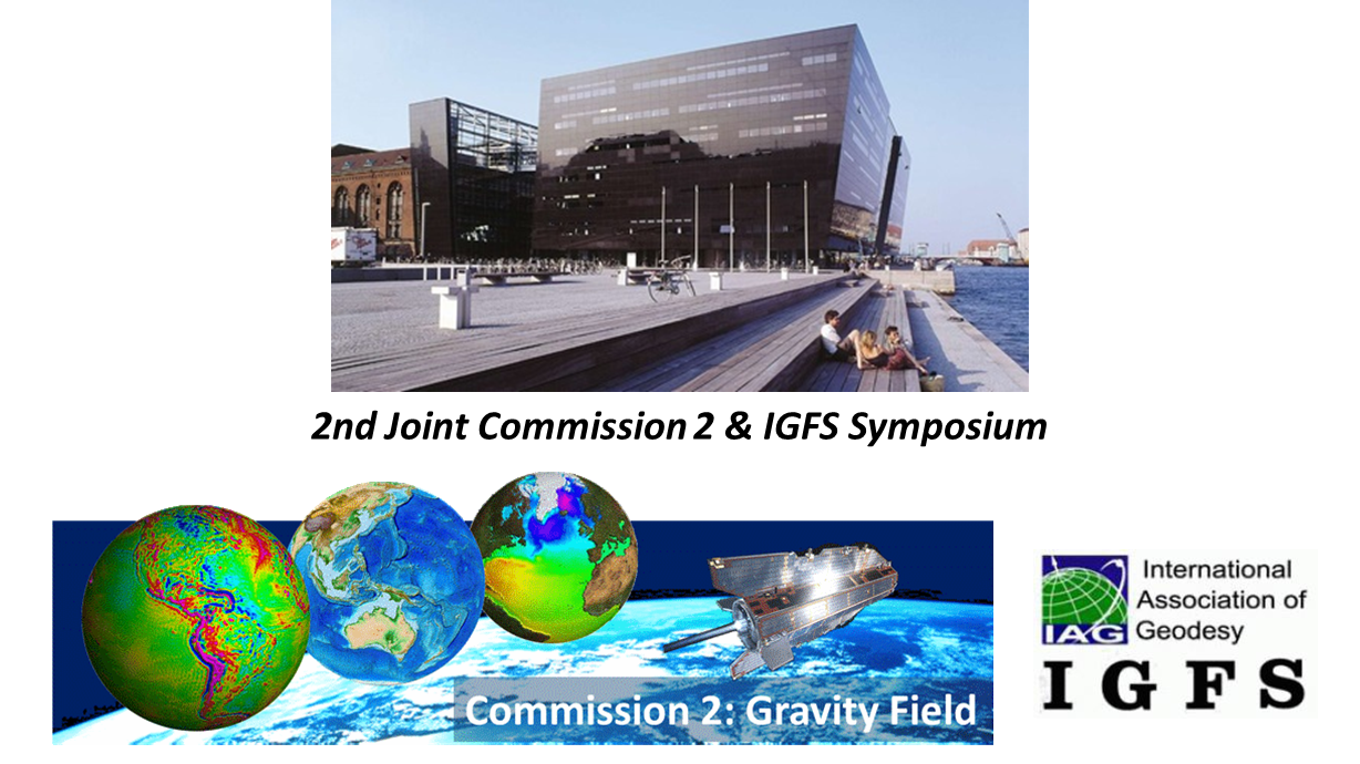
2nd Joint Symposium of IAG Commission 2 and IGFS
The GGHS2018 “Gravity, Geoid and Height Systems 2018” meeting was the second Joint IAG Commission 2 and IGFS Symposium. It took place in Copenhagen, Denmark, between September 17-21, 2018, at the “Black Diamond” conference building, which is part of the Royal Library of Copenhagen. Its main focus was on methods for observing, estimating and interpreting the Earth’s static and time-variable gravity field as well as its numerous applications.
GGHS2018 continued the long history of IAG’s Commission 2 Symposia, GGG2000 (Banff, Canada), GG2002 (Thessaloniki, Greece), GGSM2004 (Porto, Portugal), GGEO2008 (Chania, Greece), GGHS2012 (Venice, Italy), with those of IGFS, 1st IGFS Meeting 2006 (Istanbul Turkey), 2nd IGFS Meeting 2010 (Fairbanks, Alaska, USA), 3rd IGFS Meeting 2014 (Shanghai, China), and finally the first joint Commission 2 and IGFS meeting 2016 (Thessaloniki, Greece).
GGHS2018 was structured in 7 sessions spanning the entire 5 days of the program. The oral session programme was complemented by two poster sessions on Tuesday and Thursday afternoon. In the opening session on Monday morning, the whole bandwidth of geodesy could be demonstrated by four presentations covering the topics of satellite gravity missions GRACE/GRACE-FO, cold atom interferometry for gravity determination, advances in the establishment of the International Height Reference Frame (IHRF), and physical height determination of Mount Sagarmatha (Everest).
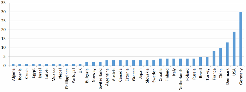
For GGHS2018, 164 abstracts have been received, out of which 87 have been scheduled as oral presentations and 77 as posters. 155 participants from 35 countries participated in the conference. It should be particularly emphasized that this symposium was able to attract also the young generation of scientists, since about 1/3 of the total number of participants were either MSc Students or PhD candidates.
The scientific program of GGHS2018 was of outstanding quality and showed significant scientific advancements in several fields of gravity field research, which are briefly summarized in the following:
- 1. Session 1: Current and future satellite gravity missions
(Chairs: Thomas Gruber and David Wiese)- A successful launch of GRACE-FO in May 29 will continue the time series of Earth mass transport. Satellites are in the IOC phase, and despite some initial challenges with the flight system, preliminary gravity fields look promising.
- GRACE data processing continues to mature, lowering error levels in the solutions, and improving geophysical interpretation. Official GRACE SDS centers have released RL06 data products, and new products from GSFC and ITSG are also coming soon.
- Reprocessing of GOCE gravity gradients and orbits is currently ongoing, and first results of pure gradiometer based gravity models indicate improvement of 20-30% globally with respect to the release 5 models. The new release 6 is expected for early 2019.
- Multiple NGGM concepts appear promising to improve spatio-temporal resolution. The focus should still be on reducing temporal aliasing errors for future missions. Further, advanced technology such as cold atom interferometry appear promising.
- Session 2: Global gravity Field Modelling
(Chairs: Dan Roman and Shuanggen Jin)- An update on NGA’s EGM2020 is in progress, final data submission should be done by March 2019.
- The performance of early satellite altimeter missions have been reviewed and improvements from SAR altimeters have been discussed.
- Signal and error of global gravity models have been assessed, and a potential impact of new GOCE/GRACE satellite models for EGM2020 has been emphasized.
- In a reprocessing campaign, the performance of GOCE data could be significantly improved, which should also be reflected in improved EGM’s.
- Improved combination methodologies for terrain and satellite for high-resolution EGMs could be developed.
- Session 3: Local/regional geoid determination methods and models
(Chairs: Jonas Agren and Hussein Abd-Elmotaal)- Various regional geoid projects have progressed and achieved better precision (examples: geomed2 for the Mediterranean sea, FAMOS for the Baltic Sea, NEVER for the Netherlands, Belgium & Dutch continental shelf).
- Improvements have been achieved in the activities of the IAG sub-commissions on gravity and geoid (e.g., Africa) and the related joint working groups (e.g., JWG 2.2.2 “The 1 cm geoid experiment”).
- A technique for validating the airborne gravity data, being a suitable alternative to cover the gravity data gaps in many places such as Antarctica, Philippines, Africa, has been proposed and tested.
- A multi-scale radial basis function modeling of regional gravity fields to improve the quality of the computed geoid/quasi-geoid has been achieved by the estimated sequential parameterization.
- Local geoid determination for various places of the world has been improved reaching the cm level (examples: USA, Croatia, Greece, Slovakia, Estonia, Latvia, etc.).
- Session 4: Absolute, relative and airborne gravity – observations and methods
(Chairs: Leonid Vitushkin and Rene Forsberg)- The session highlighted new developments in the absolute gravimetry, especially for cold atom interferometry (both static and kinematic in ships and aircraft), as well as the large-scale international coordination of absolute gravimetry (e.g. in South America). The global absolute gravity network is consolidating its efforts, and represent a global infrastructure. Exchange formats for gravimetry was proposed.
- For marine and airborne gravimetry developments continue with improved processing, new sensors, and increasing accuracy. IMU-based sensors get to the mGal level, and by the shrinking size these units could eventually be deployed on drones. Large ongoing projects, such as GRAV-D, continues to cover major regions of the globe. Land vehicle gravimetry also develops, and results at 1-2 mGal level demonstrated in China.
- Time changing gravity in connection with major geodynamic events are clearly measured, by a combination of absolute and relative gravimeters. The measured changes show good correlation with the associated vertical movements, e.g. from SAR interferometry, GPS or levelling. Superconducting gravimeters continue to measure the time varying gravity field, and there is a need to co-observation with the developing quantum gravimeters. Exceptional results of multiyear over almost thirty years measurements by superconducting gravimeter were featured.
- The status of the International absolute gravity reference system, which is under the formation according to the resolution of IAG of 2015, was also presented.
- Session 5: Height systems and vertical datum unification
(Chairs: Michael Sideris and Laura Sanchez)- Based on the corresponding IAG 2015 resolution, important activities towards the definition and realization of the International Height Reference System/Frame, such as vertical datum unification within the IHRS, and numerical experiments for the computation of IHRS coordinates (Colorado experiment), have been performed.
- Regarding standards for the IHRS/IHRF, proposals for treatment of tide system, and on parameters for a new GRS have been made.
- Studies on regional/National/Local vertical reference systems and frames have been performed in Brazil, Czech Republic, Ecuador, Germany, Japan, Philippines, Poland, Latin America, Great Lakes.
- Vertical datum unification strategies with complementary data and models have been presented, such as SAR/SARin combined with terrestrial gravity data, satellite altimetry and GOCE, hydrodynamic models, InSAR on land.
- The potential of new approaches such as relativistic geodesy and quantum sensors, chronometric levelling, optical clock networks, have been discussed and quantified.
- Session 6: Satellite altimetry and applications
(Chairs: Ole Andersen and Xiaoli Deng)- A new method using satellite gravimetry to unravel satellite altimeter record of sea level change has been discussed.
- New models of mean sea surface and dynamic ocean topography have been presented.
- Long-term altimeter records have been re-analyzed to identify non-linearities of mean sea level change.
- The prediction of Arctic bathymetry from marine gravity has been presented.
- Session 7: Mass transport and climate-relevant processes
(Chairs: Carmen Boening and Annette Eicker)
- Progress has been made on climate-related signals in Earth’s oblateness.
- Signature of sea level fingerprints in ocean bottom pressure observations was analyzed, and their importance for OBP interpretation was emphasized.
- Regional insights into drought signals could be expanded.New frontiers in using GRACE for climate model evaluation were discussed.
- The potential of NGGMs for advanced applications was explored.
- GRACE and GPS were integrated to evaluate ice mass changes and GIA errors.
In addition to the scientific programme, GGHS2018, also hosted a number of splinter meetings, where vibrant exchange of ideas took place. The following splinter meetings have been organized:
VIII. IAG Commission 2 Steering Committee meeting
IX. IGFS business meeting
X. JWG 2.1.1: Absolute gravity reference system and frame
XI. JWG 2.2: Validation of combined gravity model EGM2020
XII. Joint meeting of JWG 0.1: Strategy for the Realization of the International Height Reference System (IHRS), and JWG 2.2.2: The 1-cm Geoid Experiment (“Colorado experiment”)
XIII. NKG/NGA EGM2020 database meeting
XIV. FAMOS Baltic Sea project meeting
Significant progress has been made in response to the two IAG 2015 resolutions. The status and main conclusions are summarized below:
- Definition and realization of an International Height Reference System
- Support by SC 2.2 and associated JWG 2.2.2 (“1 cm geoid experiment”) has been shown to be highly beneficial.
- Reference point selection is almost completed.
- Processing strategies for potential values is about to converge.
- First version of IHRS should be ready by IUGG 2019.
- Establishment of a global absolute gravity reference system
- Concepts for establishing system and frame are consolidated.
- Co-location of reference sites with IHRS sites is encouraged.
- Definition of the system shall be completed before IUGG 2019.
It is encouraged to submit manuscripts related to all abstracts accepted and presented at the GGHS2018 conference (either oral or poster) in the online peer-reviewed open-access “Journal of Geodetic Science”. Specific instructions for authors have been supplied to all participants of the conference, and are available on the website http://www.space.dtu.dk/english/gghs2018/proceedings. Deadline for submission is November 30, 2018.
LOC
|
Scientific Committee
|
ROLAND PAIL
Obituary
Prof. Dr.-Ing. Hermann Maelzer (1925 – 2018)
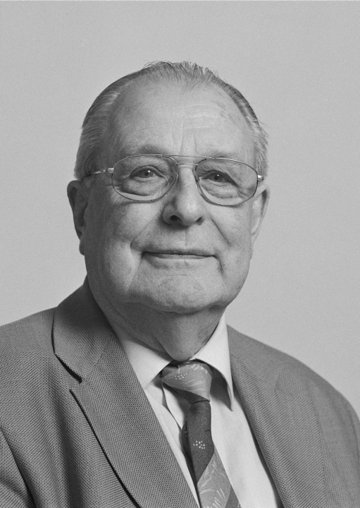
Dr. Hermann Maelzer, formerly Professor for Geodynamics at the University of Karlsruhe (now: Karlsruhe Institute of Technology, KIT) and Director of the Geoscientific Observatory at Schiltach (Black Forest Observatory, BFO) in Germany, passed away peacefully on August 20, 2018 in the blessed age of 93 years.
He was born on April 19, 1925 in Ponitz/Germany as son of a farmer. Upon completing High School and Military Service in World War II Hermann Maelzer started his career as a survey technician apprentice, before he enrolled in the geodetic programme at the Technical University of Berlin-Charlottenburg, Germany, from which he graduated with a Dipl.-Ing. degree in 1953. In the same year he married his wife Gisela, and they moved to South Germany, where Hermann Maelzer filled various positions at the Geodetic Institute of the University of Karlsruhe within the 35 years to follow until his retirement. In 1958 he received the Dr.-Ing. degree, having submitted his Doctor dissertation „On the adjustment of levelling networks by successive approximation“ to the Faculty of Civil Engineering and Surveying of the Technical University of Karlsruhe. A special highlight within the first decade was his participation in the International Glaciological Expedition to Greenland (EGIG) in 1959 and in two other scientific expeditions to Ethiopia. Triggered by these expeditions, but also caused by his activities as supervisor of the seismic station in the basement of the Geodetic Institute, he early had interdisciplinary contacts to other branches of geoscience, providing a strong impact on his further scientific work. In 1972 he additionally took over the directorate of the newly installed joint geoscientific observatory of the Universities of Karlsruhe and Stuttgart near Schiltach/Germany (Black Forest Observatory, BFO), before he finally received the status of Full Professor for geodynamics which he held until his retirement in 1988. He was an enthusiastic academic teacher - his lectures on Least Squares Adjustment and Physical Geodesy, though strongly demanding, had great impact on his students.
Undoubtedly, the most prominent achievement of the scientific life work of Hermann Maelzer is the foundation and management of the BFO, which had been installed in 1971 in a former silver mine in the Black Forest. Under his directorate the BFO, into which he put a lot of his heart, soul and time, developed to a worldwide leading geodynamic observatory. While the focus within the first decades was put on Earth tide research, later on the main interest switched to the registration and analysis of seismic signals as well as to the observation of free oscillations of the Earth (as excited by large earthquakes) and temporal changes of the Earth’s magnetic field. Due to the extremely quiet surrounding of the BFO in the crystalline rock, the broad-banded observation data possess an extraordinary low noise level and an outstanding quality, allowing the first worldwide detection of various geodynamic phenomena. The present status of the BFO is strongly tracing back to the vision, skill and expertise of Hermann Maelzer. He also maintained good contacts to other geodynamic observatories, in particular to Walferdange/Luxembourg; recognizing his merits for the cooperation of both observatories the Grand Duke of Luxembourg and Duke of Nassau handed over the „Ordre Grand Ducal de la Couronne de Chene“ to him in 1994.
Since the end of the 1960ies a second focus of Hermann Maelzer’s scientific activities was the determination of recent crustal motions from geodetic observation data, in particular from repeated precise levellings. Starting with the evaluation of levellings in the region of the Upper Rhine Graben, one of the most active seismic regions in Europe north of the Alps, he extended the analysis to other regions in Germany. Based on his expertise in this field, many years until his retirement he chaired the Working Group on recent height changes, installed by the German Geodetic Commission (DGK). This group, organized and strongly inspired by him, succeeded in publishing the first map of recent height changes in West Germany in the year 1979, based on the levelling data delivered by the surveying authorities of the Federal States of Germany. The scientific contributions of this working group were fully integrated into the aims of IAG Commission VII „Recent Crustal Movements“ (CRCM), in accordance with the geoscientific programmes of the Inter-Union Commission of Geodynamics (till 1979) and the Inter-Union Commission on the Lithosphere (ICL, since 1981). Many years Hermann Maelzer was engaged in the Directing Board of the International Centre on Recent Crustal Movements (ICRCM), acting as a central agency within the framework of the CRCM. Due to his merits for the observation and analysis of recent crustal movements and his activities in ICRCM he received the Mescherikov medal of IAG in 1991.
Hermann Maelzer was active in many scientific organisations. From 1979 until his retirement in 1988 he was an ordinary member of the German Geodetic Commission (DGK) and, among others, member of the research board of trustees „Physics of the Earth“.
Despite various strokes of fate, starting with the loss of his homeland after World War II up to the early death of his wife Gisela in 1999, Hermann Maelzer had maintained his subtle humour and his proverbial „sunny disposition“ till the end. He had a strong influence not only on the development of the Geodetic Institute in Karlsruhe in research and academic teaching, but also on the interdisciplinary cooperation within the geosciences in Germany and internationally.
His academic students, co-workers, friends and colleagues will remember Hermann Maelzer not only as a highly committed and enthusiastic university teacher and scientist, but also as a modest, kind and extremely reliable person. We are grateful to him for his extraordinary achievements and will always honour his memory.
BERNHARD HECK
Mikhail Tikhonovich Prilepin (1929 – 2018)
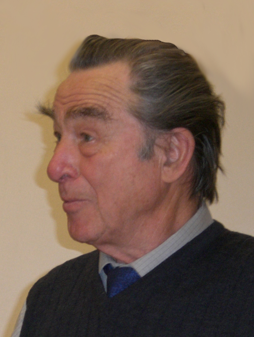
On September 19, 2018, Mikhail Tikhonovich Prilepin passed away – a well-known geodesist, doctor of technical sciences, an expert in the field of electronically-optical measurements, satellite navigation systems and geodynamics, as well as studying the deformations of the earth's crust using ground-based and satellite technologies.
Mikhail Tikhonovich was born on February 15, 1929 in the village of Kalikino in the Dobrovsky district of the Lipetsk region. His youthful years fell on hard wartime and post-war time in the town of Pokrov of the Vladimir Region. After graduating from Pokrovsk secondary school, Mikhail Tikhonovich entered the Moscow Institute of Engineers of Geodesy, Cartography and Aerial Photography (MIIGAiK), from which he graduated with honors in 1951 with a degree in astronomy-geodesy.
In 1952, he participated in the work of the Aerogravimetric Expedition of the Geophysical Center of the Academy of Sciences of the USSR, and in November of the same year he was enrolled in full-time postgraduate studies at TsNIIGAK and part-time junior research assistant.
In 1957, he defended his Ph.D thesis "The determination of the refractive index of air when measuring distances by light-modulating range finders" under the guidance of prof. A. A. Izotov.
In 1958-1959 he worked in the Syrian Arab Republic. At the Moscow Region test site, TsNIIGAK created a geodetic network in the form of a central system, which allowed to conduct research in the field of high-precision angular measurements (including due to the influence of refraction, torsion of triangulation constructions), and also to test new geodetic instruments. Since 1961 - Senior Researcher of MIIGAiK. In the article “Reduction to the surface of the reference of distances measured by light and radio range finders” (Geodesy and Cartograhy, 1956, No. 2, 19–23), M. T. Prilepin derived a formula for reducing distance measuring with a relative error of 10–7 with accuracy measurements 10-6; he also noted that when reducing the bases measured by the range finders, knowledge of the plumb line deflection is not required. Since 1966 - Associate Professor of the Department of Higher Geodesy MIIGAiK. He defended his doctoral thesis “Studies in geodetic refractometry” in 1972. From 1973 to 1983 he was a professor at the Department of Higher Geodesy at MIIGAiK.
During these years, the main direction of the scientific works of Mikhail Tikhonovich was the improvement of means and methods of high-precision geodetic determinations. They have patented and introduced methodological and technical improvements to the most diverse types of geodesic measurements, ranging from theodolite and laser distance meter to a long-range interferometer and a radio astronomical lens antenna (Japanese patent).
Since 1983, Mikhail Tikhonovich works at the Schmidt Institute of Physics of the Earth RAS. During this period, his work is mainly devoted to the study of movements of the earth's crust, as well as geodynamic and geophysical processes, including the preparation of strong earthquakes, by means of GPS. The geography of his scientific journeys is truly amazing. These are the countries of Europe, and America, Japan, Australia.
In 1997, Mikhail Tikhonovich became the head of the geodesy section of the National Geophysical Committee of Russia, replacing the world-famous gravimetry scientist Yu.D. Boulanger. Mikhail Tikhonovich until the last days was a member of the bureau of this section. He was chairman of a number of international symposia and participated in many of them in the field of solving geodynamic problems by geodetic methods. “Geodesy and seismology. Deformations and Prognosis” was the name of the international symposium on the anniversary of the Spitak earthquake, held by Mikhail Tikhonovich in Yerevan in 1989. He was the editor and author of several issues of the National Report on Geodesy submitted to the General Assembly of the International Union of Geodesy and Geophysics. M.T. Prilepin is one of the first organizers of observations of the movements of the earth's crust on the territory of the USSR and Russia using modern navigation satellite systems. Especially vigorously, he studied the Caucasus region as part of an international group. His works are actively quoted by Russian and foreign scientists. He is widely known in European as well as international scientific circles. The scientific heritage of Mikhail Tikhonovich includes more than 240 scientific papers. He is among the 100 most cited Russian geophysicists. Honorary Professor of MIIGAiK, awarded the medals "Veteran of Labor" and "In memory of the 850th anniversary of Moscow." Over the years, he received numerous commendations from the leadership of the IPE RAS.
In the International Association of Geodesy (IAG), Professor M.T. Prilepin served as the Secretary of IAG Section I (Positioning) (1983-1987 and 1987-1991), President of Section I and a member of IAG Executive Committee (1991-1995). As a very active member he was invited in a number of IAG Special Study and Working Groups. For his great contribution he was awarded “IAG Fellow” in 1991. He was the IAG Correspondent of Russia and former USSR between 1991-2007 in four periods of IAG activity.
Mikhail Tikhonovich brought up more than one generation of scientists. His numerous graduate students successfully work both in our country and abroad.
Mikhail Tikhonovich was a caring, loving father and spouse. He raised a daughter and two sons, all inherited a commitment to the exact sciences. One of the sons continues to be engaged in applied scientific research close to geophysics. Mikhail Tikhonovich was a kind and wise mentor to grandchildren. He conveyed his love of physics and astronomy to his granddaughter, who conducted active research in theoretical physics of elementary particles.
In life and work, Mikhail Tikhonovich was demanding of both himself and others, but at the same time he was always very kind and fair. So we will remember him forever.
SPIRIDONOV E.A., POPADIEV V.V.
| DOCUMENTS |
| IAG_Newsletter_October_2018.pdf |