April 2021

General Announcements
- IAG 2021
- Juhani Kakkuri: Memoirs from the World of Geodesy
- Development of free software packages for analyzing terrestrial and airborne gravity data in Indonesia
Meeting Calendar
IAG Sponsored Meetings
- EUREF 2021 Symposium
- 19th International Symposium on Geodynamics and Earth Tides (G-ET Symposium 2021)
- IAG Scientific Assembly
- The 6th Satellite Soil Moisture Validation and Application Workshop
- IGS Workshop "IGS 2021: Science from Earth to Space"
- Unified Analysis Workshop 2021
- GGOS Days 2021
- 20th Assembly of WEGENER
- 2nd International Symposium of Commission 4: Positioning and Applications
IAG Related Meetings
- AOGS Annual 18th Meeting
- COSPAR 2022
Reports
- Virtual Workshop on Satellite Observations and Modelling of GRACE Data for Terrestrial Applications
Obituary
- Dezső Nagy (1930-2020)
General Announcements
IAG 2021
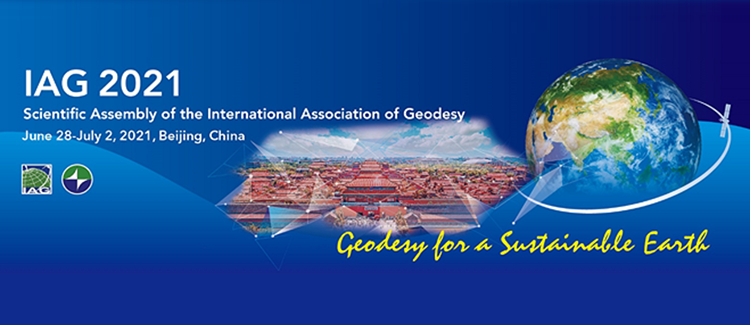
The IAG Scientific Assembly will be held in Beijing on
June 28–July 2, 2021. The Scientific Assembly is a quadrennial event, in the
middle of the periods between the IUGG General Assemblies. Due to the ongoing
COVID-19 pandemic, the Scientific Assembly will be organized as a virtual
meeting. Due to the exceptional and challenging circumstances, it took time to finalize
all details and to ensure that we will have a full and high-quality programme.
The Theme of the Symposium is Geodesy for a Sustainable Earth. There will be eight Symposia, with topics covering the activities of IAG Commissions, Services, Inter-Commission Committees and a timely topic on Geohazards. Full list of the scientific programme and sessions therein can be found on the official web site http://www.iag2021.com. The web site is open for registration and abstract submission.
Important dates and deadlines
(see more details on the web site http://www.iag2021.com)
| Registration Deadline: | June 25 |
| Abstract Submission Deadline: | May 7 |
| Acceptance of the Abstracts: | May 18 |
| Pre-recorded video upload Deadline: | June 8 |
| E-poster upload Deadline: | June 8 |
| Scientific Assembly: | June 28-July 2 |
The local organizers and the IAG have worked to keep on-line registration fee as low as possible, and IAG individual members receive a discounted fee. For non-IAG members the fee is US$ 150, and for IAG members US$ 75. Abstract submission fee is US$ 40. Additionally, the participation fee will be waived for members of several groups, who must send a request to the Secretary General of the IAG to receive this fee waiver:
- Full-time students from undergraduate to PhD students, who must also submit a student certificate or letter from their department.
- Early career scientists (below age 35) if they have an accepted presentation (oral or poster) in the Symposium.
- Scientists from developing countries.
Opportunity for free, open access publication in the IAG renowned Symposia Series
The Assembly participants are invited to submit an abstract for oral or poster presentation at one of the Symposia. Authors of accepted presentations (oral or poster) are welcome to offer the full paper in the IAG renowned Symposia Series published by Springer. This series is now fully Open Access and the primary mode of publication is on-line (individual papers, and an e-book once all papers are finished). The papers will be on-line and Open Access shortly after each paper is accepted, so that they do not have to wait for the entire volume to be completed. All papers will eventually be searchable through the volume once the volume is finalised. The Open Access fees for the IAG Scientific Assembly participants are covered by the IAG; thus, the first author shall be the participant of the Assembly. The IAG Symposia Series is indexed in Web of Science (book by book) and in Scopus (as a series).The LOC and SOC have done their best that the Symposium will offer a full experience regardless of the demanding circumstances. We have increased the interactive part of sessions with the possibility of meeting speakers virtually and having discussions with them. Poster sessions will also have interactive possibilities and to ask questions of the authors.
We hope to see you in the IAG Scientific Assembly 2021. You are very warmly welcome.Markku Poutanen
IAG Secretary General.
Juhani Kakkuri: Memoirs from the World of Geodesy
The autobiographical book of Professor Emeritus Juhani Kakkuri, Memoirs from the World of Geodesy, has appeared. “To make my dream of becoming a professor come true, I had to study, and to be able to study, I had to earn some money. Consequently, I worked summers as a fieldworker at the Finnish Geodetic Institute.” Juhani Kakkuri was a civil servant at the Finnish Geodetic Institute, FGI, for more than forty years, as a field assistant, geodesist, head of department, and in 1977−1998 professor and Director General. After his retirement, Kakkuri has written several popular books related to geodesy and his travels, as well as the biographies of Veikko Heiskanen and T. J. Kukkamäki, which have also been translated into English.
In this autobiographical book, Professor Kakkuri tells of many stages of his life, his work at the Finnish Geodetic Institute, colleagues, and his numerous, sometimes very exotic, travels around the world. The Finnish-English bilingual book is available at https://helda.helsinki.fi/handle/10138/328497?locale-attribute=en.
Markku Poutanen
IAG Secretary General
Development of free software packages for analyzing terrestrial and airborne gravity data in Indonesia
In order to support the establishment of a reliable geoid model over Indonesian region, we have developed two software packages: pyGABEUR-ITB dan AiNG-ITB. While the former packages were developed to adjust terrestrial gravity data, the later one is to analyze airborne gravity data. Brief descriptions of both software are presented below. The packages are free for public upon request.
pyGABEUR-ITB
pyGABEUR-ITB (Python GayaBEUrat Relatif – Institut Teknologi Bandung) is an interactive software for accurate adjustment of the relative gravimeter data, developed based on Python programming language. The term “GayaBEUrat Relatif” (from mixed Sundanese-Indonesian words) means relative gravity. pyGABEUR-ITB is fully written using Python language and is freely available for public. pyGABEUR-ITB can adjust relative gravity measurements and provide reliable estimates for correcting instrument’s systematic errors, such as gravimeter drift. Furthermore, pyGABEUR-ITB can also detect possible outliers in the observations using the -criterion method. Since pyGABEUR-ITB uses the weighted constraint adjustment, at least one fixed station is required accordingly. Relative gravimeter data around Palu-Donggala area (Central Sulawesi) observed by Division for Gravity Control Network, Geospatial Information Agency, were used to test the performance of pyGABEUR-ITB. The processing results were then compared against those calculated using GRAVNET software. The comparisons show that both pyGABEUR-ITB and GRAVNET softwares statistically provide simillar results, with the total RMS value of about 5 Gal. In term of computer’s requirement, pyGABEUR-ITB can be excecuted under a computer with the following minimal requirements: x64 CPU, 1 GB memory and WINDOWS 7 OS. Finally it is important to mention that pyGABEUR-ITB is recently suited to process the data from the gravimeter that adopts the principle of vertical spring balance. In the near future, pyGABEUR-ITB will be extended to be able to automatically adapt the use of various observation principles. Main module of pyGABEUR is depicted in Figure 1.
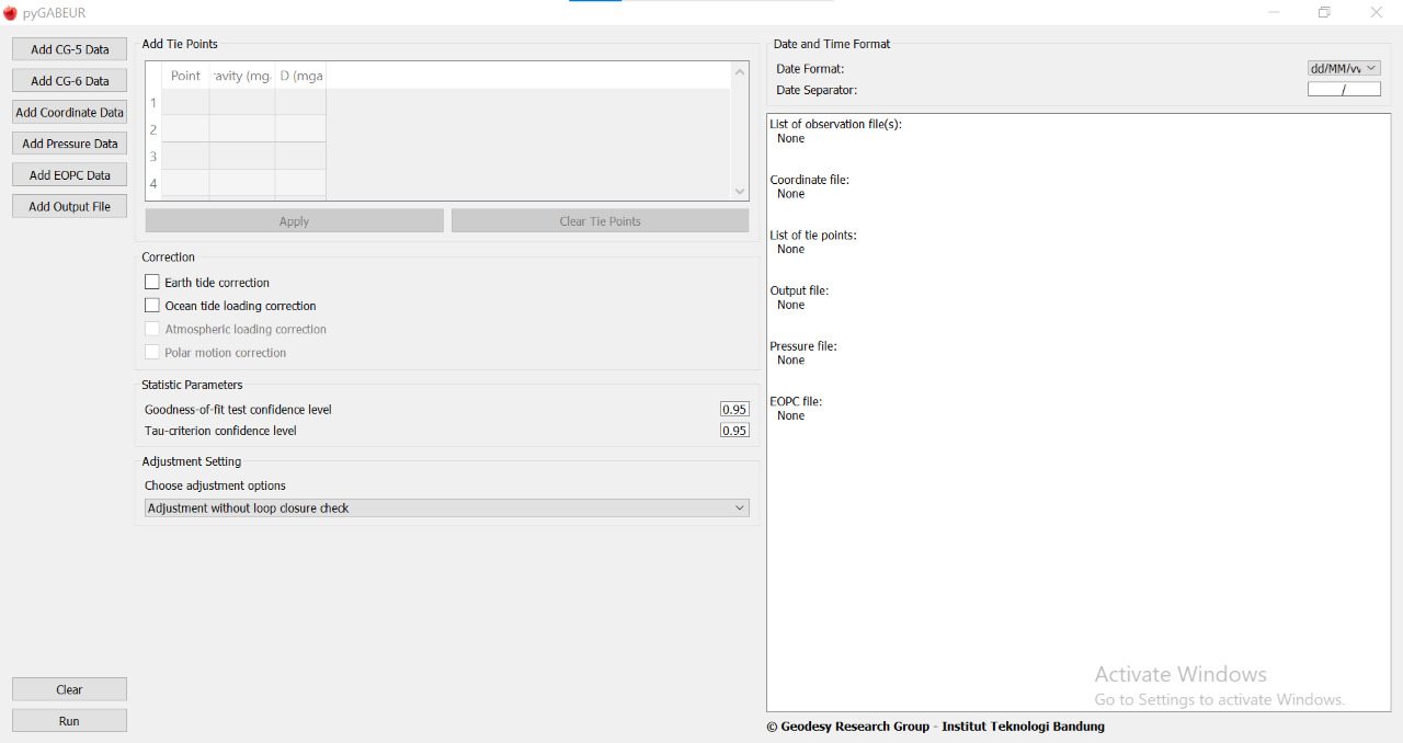
Figure 1 py-GABEUR
AiNG-ITB
To enable users performing airborne gravimetry data processing, we have developed an interactive software called AiNG-ITB (Airborne gravity data Processing – Institut Teknologi Bandung). AiNG-ITB is fully developed in Matlab® language and allows users to carry out data processing in scalar airborne gravimetry, obtaining free-air gravity anomaly and free-air gravity disturbance on flight height trajectory. AiNG-ITB reads LaCoste and Romberg (LCR) air/sea type gravimeter readings and Global Navigation Satellite System (GNSS) based positions output and corrects gravity readings from such disturbances, i.e., vertical acceleration of aircraft, Eötvös effects, misalignment of platform gravity effects, and cross-coupling effects. The systematic error due to the lag time between operating hardware, i.e., LCR and GNSS, is corrected using the cross-correlation technique. Air turbulences create high-frequency random errors in gravity readings, which amplitude could reach a few thousand mGal. Hence, we apply an adjustable lowpass filter that enables users to specify the cut-off frequency based on the performed airborne survey characteristic. In the present version of AiNG-ITB, we implement the Finite Impulse Response method with either Blackman or Blackman that can be chosen to perform such computation. For the determination of the free-air gravity anomaly and free-air gravity disturbance, AiNG-ITB uses the second-order free-air correction and Somigliana-Pizetti normal gravity estimation. Additionally, atmospheric correction is applied to correct atmospheric’ s systematic errors. The bespoke procedures can be done in either single or batch processing scenario in AiNG-ITB. The main window of AiNG-ITB is presented in Figure 2. In the present time, we use AiNG-ITB to process data in the recent airborne gravimetry survey of Java, Indonesia. We will also implement more modules, which allow users to perform an extended analysis shortly.
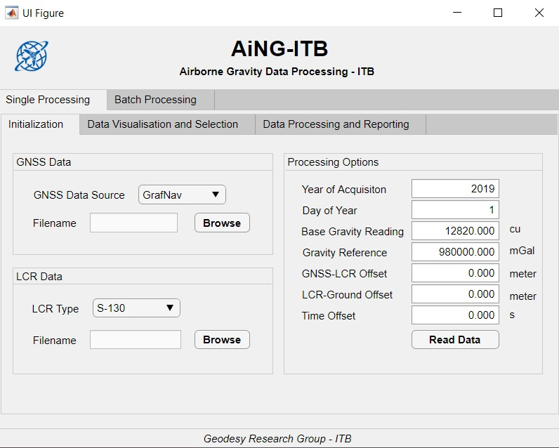
Figure 2 AiNG-ITB main program
Geodesy Research Group, Faculty of Earth Science and Technology,
Institute of Technology Bandung, Jalan Ganesha 10, Bandung, Indonesia
Meetings Calendar
IAG Sponsored Meetings
- EUREF 2021 Symposium, May 26-28, 2021, Ljubljana, Slovenia, URL: https://euref2020.si/
- 19th International Symposium on Geodynamics and Earth Tides (G-ET Symposium 2021), June 22-26, 2021, Wuhan, China, URL: http://get2020.csp.escience.cn/dct/page/1
- IAG Scientific Assembly June 28 – July 5, 2021, Beijing, China URL: http://www.iugg.org/meetings/assemblies.php
- The 6th Satellite Soil Moisture Validation and Application Workshop, September 14-16, 2021, Perugia, Italy
URL: http://venti-eventi.com/ - IGS Workshop "IGS 2021: Science from Earth to Space", September 27-October 1, 2021, Boulder, CO, USA URL: https://www.igscb.org/workshop2021/
- Unified Analysis Workshop, October 5-8, 2021, Munich, Germany
URL: https://ggos.org/event/unified-analysis-workshop-uaw-2021/ - GGOS Days 2021, October 11-13, 2021, Munich, Germany
URL: https://ggos.org/event/ggos-days-2021/ - 20th Assembly of WEGENER, october 25-29, 2022, Marrakech, Morocco, URL: https://wegener2021.sciencesconf.org
- 2nd International Symposium of Commission 4: Positioning and Applications, September 5-9, 2022, Potsdam, Germany, URL: https://iag-commission4-symposium2022.net/
IAG Related Meetings
- AOGS Annual 18th Meeting, August 1-6, 2021, Singapore, URL: http://www.asiaoceania.org/society/public.asp?view=up_coming
- COSPAR 2022, July 16-24, 2022, Athens, Greece
URL: https://www.cospar-assembly.org
Further details are available in the IAG Event Calendar at: http://www.iag-aig.org/events.
Reports
Virtual Workshop on Satellite Observations and Modelling of GRACE Data for Terrestrial Applications
One of the most significant global challenges of the 21st century is securing freshwater for meeting of the requirements of worldwide population growth and sustaining natural ecosystems. Equally important is preparing well informed hazard resilience society. Space geodetic observations have been extensively utilized to monitor and understand terrestrial water variability, constraining regional and global hydrological models and consequences of variations on lithospheric deformations. These information can aptly assist in decision making for water resource managements and hazards. Realising tremendous scientific and societal benefits of exploiting satellite observations, Department of Science & Technology, Government of India (DST) has initiated a multi-institutional research project on “Assessment of Regional Hydrological System using Space Borne Gravity Observations”. Under auspices of this project, CSIR-National Geophysical Research Institute (CSIR-NGRI) has organized a Virtual Brainstorming Session on “Satellite Observations and Modelling of GRACE Data for Terrestrial Applications” on 09 February 2021. The Brainstorming Session consisted of three oral sessions, including panel discussions with 19 speakers and 65 participants from India and abroad. The updated knowledge on emerging trends in satellite observations and modelling for Hydrological Applications, Crustal Deformations, Natural Disasters like earthquakes, landslides, Climate change, etc.
V. M. Tiwari, Director, CSIR-NGRI and National Coordinator of GRACE Network Project, has initiated the meeting by welcoming participants and presented an update of the projects on Assessment of Regional Hydrological System. Debapriya Dutta, Head of NGP, DST has informed about India’s geospatial policy and emerging opportunities for research and development in Geospatial science. The distinguished speaker, Raj Kumar, Director NRSC, ISRO emphasized about utilization of GRACE data products in combination of terrestrial groundwater and remote sensing data sets for improved understanding of mass variations at the surface and beneath the surface of the earth. B Srinivas, Director, CSR, UT, USA spoke on ‘Overview of GRACE and FO mission Data”. Matthew Rodell, Deputy Director for Hydrosphere, Biosphere, Geophysics, Earth Sciences Division, NASA, USA, presented the Hydrological applications of Satellite Gravimetry observations monitoring water resources with GRACE and GRACE-Fo data products. He also showed anticipated future changes in groundwater recharge and water cycle. Prakash Chauhan, Director, Indian Institute of Remote Sensing, Dehradun, has delivered a lecture on “Cause and Process Mechanism of Rockslide Triggered Flood Event in Rishiganga and Dhauliganga River Valleys, Chamoli, Uttarakhand, on 07 February 2021. He discussed the potential cause of rockslide and the process mechanism of this unique event, causing loss of lives and property besides widespread devastation. In addition to the above mentioned special lectures, several significant topics like - improving spatial resolution of GRACE products in India, small scale modelling with GRACE and WHGM, Hydro-geodesy–Geodesy to the aid of hydrology and Non-Tectonic deformation in Tectonic geodesy and so on were also discussed. This brainstorming would pave a way forward for evolving major national and international science employing satellite observations.
Contact
Virendra M. Tiwari
National coordinator of the Grace network project.
Director, CSIR-NGRI
Hyderabad-India.
Email: vmtiwari @ ngri.res.in
Obituary
On the 11th of December, 2020. Dr. Dezső Nagy, MSc surveyor, emeritus researcher of the Geodetic Survey of Canada (presently named as Geodetic Survey Division, Natural Resources Canada) passed away in his home in Ottawa, Canada due to a lethal disease. Although his incurable health problem was known the notification on his death did cause pain of heart for all who knew him personally and had contact with him.
Dezső Nagy was born on the 19th of April, 1930 in Hajdúdorog, Hungary. He finished his studies at the secondary school (lyceum) of his home town in 1948. He was graduated at MSc level at the Faculty of Civil Engineering of the Technical University of Budapest as a surveyor in Sopron in July, 1953. After graduation he won a 3 year stipend of the Hungarian Academy of Sciences and his studies and research work were led by Prof. Dr. István Hazay and Prof. Dr. Antal Tárczy-Hornoch. He spent the first two years in the Central Research Laboratory of Optics and Precision Mechanics supervised by Dr. Ferenc Szalkay. He left Hungary after the fall of the revolution in 1956 and his MSc degree was reaffirmed at the University of Toronto (UT) in 1958. His thesis work was dedicated to electronic distance measurement. After finishing his PhD studies in the field of geoid determination he got his PhD degree at UT by the dissertation “Geoidal Contours” in 1962.
He attended several training courses organized by different universities of Canada and the USA (Advanced Digital Computer Programming, University of Pennsylvania, 1965; Special Summer Institute in Dynamical Astronomy, Cambridge, MA, 1969; Advanced TeX/Macro Writing Course, Carleton University, 1988; Desktop Publishing, Toronto, 1990).
In 1961 he moved from Toronto to Ottawa where he was applied as a scientific researcher of the Gravity Division of Dominion Observatory. He has worked for it since 30th of March, 1961 until his retirement in 1993 but he was active as an emeritus researcher up to 2012.
The focus of his interest was on the problems of geoid determination but he coded also unnumbered algorithms to solve the general routine tasks of the Gravity Department by computers.
He was the first scholarship holder of the computing centre of UT where he started his computations related to his PhD dissertation in 1958. The main output of his PhD work was a computer code written for the determination of the gravimetric deflections of the vertical by the linearization of the Stokes function. The block average (representative value) of the gravity data was provided by the determination of bivariate polynomials the accuracy of which was investigated by the inverse matrix of the least squares adjustment. This way the computations could be run with minimum user interactions. For the rigorous solution of the Stokes integral, however, a worldwide coverage of gravity data has to be provided. The necessary data outside the area of Canada were obtained from the data bases of the Ohio State University, Goddard Space Flight Center and the Bureau Gravimetrique International. He wrote a program code also for the solution of large linear equation systems which was implemented successfully for the gravimetric base network of Canada in 1961.
He developed some forward 2D and 3D program codes in Fortran language to help the geological interpretation of gravity anomalies. He applied intensively the Monte Carlo and the Fast Fourier Transform methods in his investigations. Beyond all the tasks mentioned above he was in charge of the accuracy analysis of the gravity data base of the Dominion Observatory and of the visualization of data both by contour and 3D anaglyph plots. All the related program codes necessary for the computations of map projections and transformation were developed by him too. He edited maps of geoid undulation and gravity anomaly data derived from global geopotential models provided by satellite observations. The length of the codes written by him in Fortran language exceeds 280 000 program lines.
A closed expression for a specific solution of the Newton integral proposed by him was published in Geophysics in 1966. It describes the gravitational effect of a right rectangular parallelepiped (prism) and his paper resulted in more than 600 citations and unnumbered applications in scientific research since its publication. The great theoretical advantage of the modelling by prisms is its rigorousness regarding analyticity. The functional relations between the different parameters (potential, geoid undulation, first and higher order derivatives of the potential, etc…) of the gravitational field generated by the prism (or a set of prisms) can be investigated without the application of any kind of numerical approximations. Dr. Nagy had a strong intention to optimize his program code regarding both numerical accuracy and computation time. The best version of the algorithm consists of only 7 Fortran code lines.
He was an active member of some working groups of the International Association of Geodesy (IAG SSG 5.100, IAG SSG 3.113, IAG SSG 3.116) and the Geoid Commission of Canada between 1986 and 1993. He participated in several joint research projects with colleagues working for University of New Brunswick, National Geodetic Survey, USA and Naval Postgraduate School, California. Between 1963 and 2010 he attended many domestic and international scientific conferences, meetings and workshops where he usually gave talks on his research results. He published more than 200 papers a significant number of which is without co-author.
He was also extremely interested in the continuously evolving presentation methods of research results using always the up to date computer tools and software. Hence he has programmed his presentation slides, posters and graphics by himself applying PostScript language since the appearance of personal computers.
Since 1990 when the iron curtain fell and Hungary got back its political independence from the Soviet Block he has had a fruitful cooperation with the researchers of the Geodetic and Geophysical Research Institute of the Hungarian Academy of Sciences, Sopron (GGRI). They published several joint papers on interpolation techniques and geoid modelling. The one dedicated to the investigation of the analytical/numerical behaviour of the formulae he derived for the description of the gravitational field generated by a prism was published in Journal of Geodesy in 2000. He wrote also some papers for the journal of Hungarian surveyors “Geodézia és Kartográfia” to share his high level knowledge on topics related to geodesy and geodetic research. During his visits to Sopron and Budapest he always gave talks on his research and development results at least 20 times. He was a member of the advisory board of the journal Acta Geodaetica et Geophysica Hungarica published by the Hungarian Academy of Sciences from 1994 to 2010. His activity in Hungary was supported by the agreement between the Geodetic Survey of Canada and the GGRI, Sopron negotiated in 1991. Later on this agreement was renewed several times.
His outstanding professional activity was honoured by gold and diamond certificates in 2003 and 2013, respectively, by the Technical University of Budapest. He became an honorary member of the Hungarian Society of Surveying, Mapping and Remote Sensing in 2013.
Rest in peace. His kind and helpful personality and professional achievements will be commemorated for a long time.
József Ádám – Gábor Papp
The IAG Newsletter is under the editorial responsibility of the Communication and Outreach Branch (COB) of the IAG. It is an open forum and contributors are welcome to send material (preferably in electronic form) to the IAG COB (newsletter@iag-aig.org). These contributions should complement information sent by IAG officials or by IAG symposia organizers (reports and announcements). The IAG Newsletter is published monthly. It is available in different formats from the IAG new internet site: http://www.iag-aig.org.
Each IAG Newsletter includes several of the following topics:
- news from the Bureau Members
- general information
- reports of IAG symposia
- reports by commissions, special commissions or study groups
- symposia announcements
- book reviews
- fast bibliography
| DOCUMENTS |
| April2021.pdf |